Flower's Cove
Flower’s Cove is located on the Northwestern edge of Newfoundland’s Great Northern Peninsula. Because of its unique location on low, sandy spits, the town itself can be seen from a fair distance on the main highway. The town proper incorporates the nearby communities of Nameless Cove, Mistaken Cove, as well as a stretch of islands and inlets that include Seal Islands, Seal Ledges, Flower's Island and Flower's Ledges. Because of these protective islands, the settlement of Flower’s Cove is one of the only well sheltered communities along The Straights.
According to local legend, the name ‘Flower’s Cove’ was coined by Captain James Cook during his 1764 mapping expedition. At this time, the word ‘flowers’ was often used to describe rocks that appeared on the surface of the water. Due to the numerous breakers at the entrances of local coves, this name would have seemed appropriate for the settlement.
Historically, Flower’s Cove was situated near excellent cod-fishing grounds and was also in the path of a major spring seal migration. French settlers were drawn to these two industries and helped to establish a community here. In these early years, the French regarded the Flower's Cove vicinity as their own and discouraged English fishing and settlement. This changed around 1850 with arrival of two English families—the Whalens and Carnells— whose arrival marked the beginning of English settlement in the region.
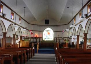
With the fishery long gone, this community now operates as a business and administrative center for the GNP. It features a fish plant, restaurants and accommodations. Of the many landmarks, one of the most historic is the ocean-side Anglican Church, known locally as the Seal Skin Church. This church is an original early twentieth century structure and got its nickname from how it was originally built using funds from the sale of locally crafted sealskin boots.
- The Flower's Cove 'Sealskin' Church
- Laura Chamber's knitting skills
- Odette and Pius' Newfoundland Quilts