GISciences Diploma Program
The diploma program in Geographic Information Sciences (GISciences) is a 30 credits program offered, by the Department of Geography, to students registered in a Bachelor of Arts or in a Bachelor of Science.
The diploma program is also offered to students who have completed a Bachelor of Arts or Bachelor of Science at Memorial University or at another recognized university.
The diploma in GISciences consists of a series of courses in cartography, geographical information systems, and remote sensing. Two instructional field placement courses provide the students with opportunities to use their skills and to apply their knowledge to industry-related problems.
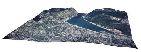
Throughout the program, students will learn to compile geo-referenced databases, design and produce maps, analyze data in geographic information system environments, produce digital elevation models, and extract information from aerial photographs and satellite images.
Students who complete the diploma will understand and appreciate how cartography, geographic information systems and remote sensing are integrated with one another.
The diploma in GISciences is of interest to people in many fields; it is a valuable complement to undergraduate studies in social and natural sciences programs such as anthropology, biology, computer sciences, earth sciences, economics, engineering, environmental sciences, geography, health and medicine, history, physical oceanography, political sciences, resource management, and the study of languages.
Cartography, geographic information systems, and remote sensing provide effective methods of gathering, managing, analyzing and representing geographic information.
- Cartography involves the compilation, organization, and visual representation of spatial information in a presentational form (i.e. map) that efficiently communicates geographic relationships.
- Geographic information systems enable the compilation, organization, and processing of spatial (i.e., maps) as well as non-spatial (i.e., text, statistics, and graphs) data. Socio-economic, political and environmental management decision-making is supported by the results of geographic information system analyses and modeling.
- Remote sensing images, recorded from aircrafts and satellites, provide resourceful information to observe and study the cultural and physical landscapes. Examples of remote sensing applications include land cover mapping, environmental quality evaluation, and natural resources exploration, assessment and monitoring.
Program Coordinator
For more information students are invited to contact the Program Coordinator. Please see http://www.mun.ca/hss/about/contact/coordinators.php for current contact information.