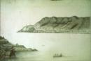
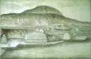
| | Photo Title: Drawing of St. John's Harbour, Newfoundland
Collection Title: Slides illustrating Newfoundland,17th-19th centuries
Image No.: PF-053.010
Description: Fishing in St. John's Harbour. Fort Amherst in the background
Image Location: Box12/pf053_010.jpeg
|
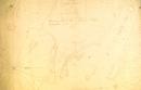
| | Photo Title: Drawing of flakes and stages at Quidi Vidi, St. John's, Newfoundland
Collection Title: Slides illustrating Newfoundland,17th-19th centuries
Image No.: PF-053.011
Image Location: Box12/pf053_011.jpeg
|
| | Photo Title: Drawing of flakes and stages at Quidi Vidi, St. John's, Newfoundland
Collection Title: Slides illustrating Newfoundland,17th-19th centuries
Image No.: PF-053.012
Image Location: Box12/pf053_012.jpeg
|
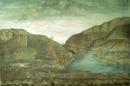
| | Photo Title: Drawing of flakes, stages and buildings near St. John's, Newfoundland
Collection Title: Slides illustrating Newfoundland,17th-19th centuries
Image No.: PF-053.013
Image Location: Box12/pf053_013.jpeg
|

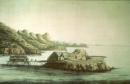
| | Photo Title: Painting of St. John's Harbour, Newfoundland
Collection Title: Slides illustrating Newfoundland,17th-19th centuries
Image No.: PF-053.014
Description: St. John's Harbour showing flakes, stages, sailing vessels, and livestock.
Image Location: Box12/pf053_014.jpeg
|
| | Photo Title: Plan of Ferryland Harbour and Capeling Bay in Newfoundland
Collection Title: Slides illustrating Newfoundland,17th-19th centuries
Image No.: PF-053.015
Description: Scale bar at lower centre says, "A Scale of 80 chains on one English Mile".
Image Location: Box12/pf053_015.jpeg
|
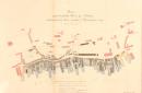
| | Photo Title: "Plan of part of the Town of St. John's destroyed by fire on the 21 November 1817."
Collection Title: Slides illustrating Newfoundland,17th-19th centuries
Image No.: PF-053.001
Description: Plan of part of the town of St. John's, Newfoundland destroyed by fire on the 21 November 1817
Image Location: Box12/pf053_001.jpeg
|
| | Photo Title: "Plan of part of the town of St. John's destroyed by fire on the 21st November 1817."
Collection Title: Slides illustrating Newfoundland,17th-19th centuries
Image No.: PF-053.002
Description: Plan of part of the town of St. John's, Newfoundland destroyed by fire on the 21st November 1817
Image Location: Box12/pf053_002.jpeg
|
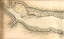
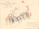
| | Photo Title: Left side of plan of Aquaforte Harbour, near Ferryland, Newfoundland
Collection Title: Slides illustrating Newfoundland,17th-19th centuries
Image No.: PF-053.003
Description: "A plan of Aqua Fort Harbour found near Ferryland in Newfoundland surveyed September the 12th 1752 by Edmund Scott Hylton." Shows some topography and soundings. Left side of total plan.
Image Location: Box12/pf053_003.jpeg
|
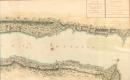
| | Photo Title: Right side of plan of Aquaforte Harbour, near Ferryland
Collection Title: Slides illustrating Newfoundland,17th-19th centuries
Image No.: PF-053.004
Description: "A plan of Aqua Fort Harbour found near Ferryland in Newfoundland surveyed September the 12th 1752 by Edmund Scott Hylton." Shows some topography and soundings. Righthand side of total plan.
Image Location: Box12/pf053_004.jpeg
|
1